
Every organization we link to: local tourism offices, the state and federal agencies that manage the land, the nonprofits and clubs that keep access open, and the universities doing the research.
West Virginia has roughly 1.5 million acres of public land and a handful of places that carry almost all of the attention. The consequence is that a great deal of very good ground sits nearly empty, usually for one of three reasons: nobody has heard of it, the road in is gated or rough, or it is undeveloped and has nothing to advertise. Those are the places below — of them across regions.
Almost Heaven Swings
What the Radio Quiet Zone is
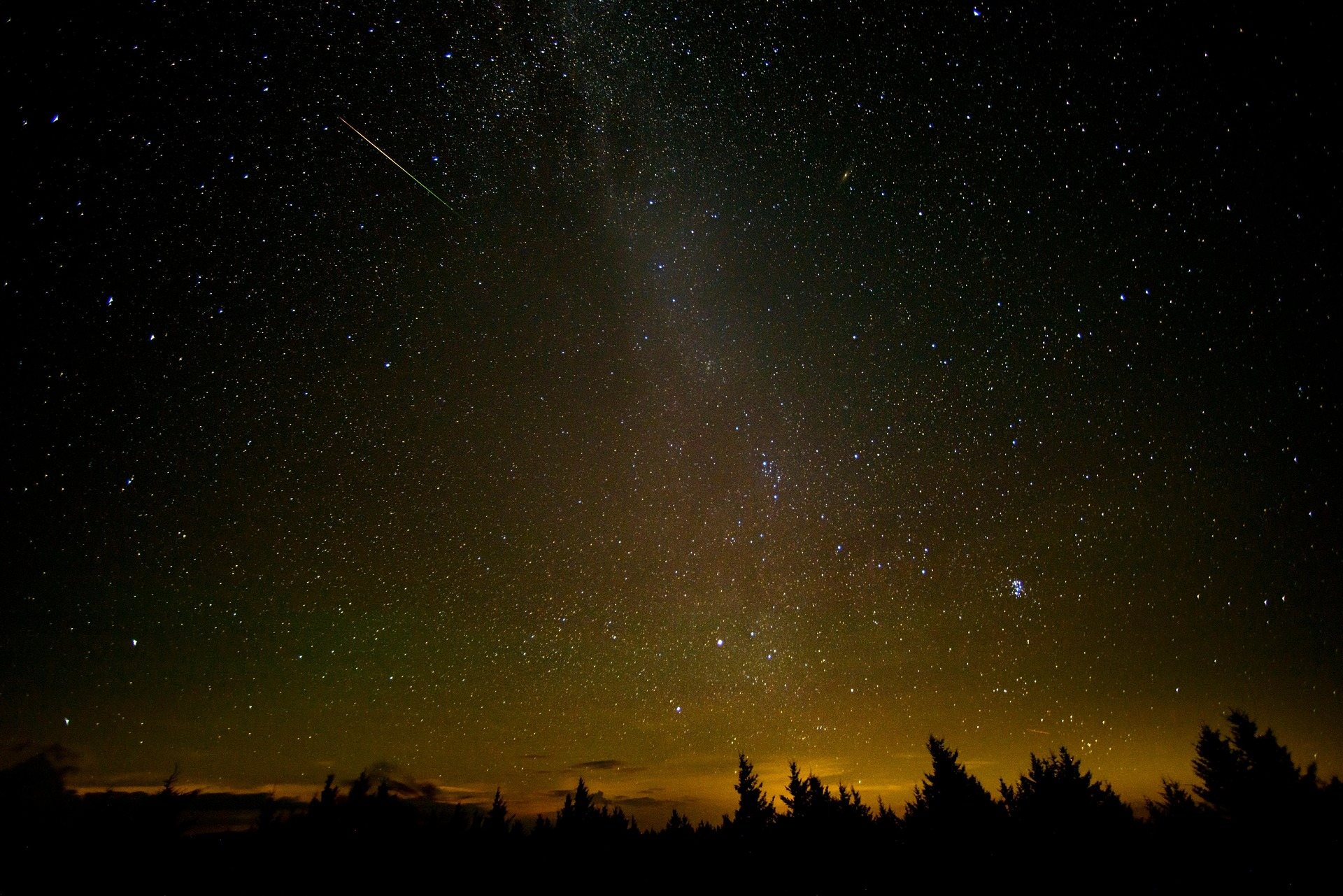
Green Bank Observatory stargazing is a side effect of radio astronomy rather than a program anyone designed. The observatory operates the world's largest fully steerable radio telescope, a structure 485 feet tall standing in a Pocahontas County valley, and it sits at the center of the National Radio Quiet Zone — a 13,000-square-mile area in which radio transmissions are restricted by law. The restriction exists for a technical reason: the telescope listens for signals faint enough that ordinary human broadcasting swamps them completely, so the quiet is not a preference but an operating requirement for the instrument.
The zone is a legal boundary rather than a park, and it covers a large piece of eastern West Virginia and adjoining Virginia. Nothing about it is fenced, gated or signed at the edges, and you will cross into it without noticing. What it has produced over decades is a region where the usual accretion of transmitters, towers and the development that follows them never happened, and where the night sky was left largely alone as a consequence. The practical outdoor result is that this is among the darkest and quietest country in the eastern United States.
Why the sky above it is so dark
Radio quiet and optical dark are not the same thing, and it is worth understanding why they arrived together here. Restricting radio transmission does not directly turn off streetlights. What it does is make a place unattractive to the sort of development that brings streetlights, parking lots, gas station canopies and the orange glow that washes the Milky Way out of the sky across most of the eastern seaboard. Pocahontas County stayed rural, forested and thinly settled, and the observatory's own operations depend on it staying that way for as long as the telescope runs.
For an observer that means the limiting factor on any given night is weather rather than light pollution. The observatory notes exceptional astrophotography conditions here, and the same conditions serve someone with no equipment at all. On a good night you are under a sky with no dome of light on any horizon — the thing most people on the East Coast have never actually seen and tend not to believe in until they are standing beneath it. Your eyes, twenty minutes of dark adaptation and somewhere to lie down cover most of what you need.
Planning the night
Plan around the new moon. That is the observatory's own advice for astrophotography here, and it applies just as strongly to naked-eye viewing: a bright moon undoes a dark sky far more thoroughly than a distant town does, and a full moon on an otherwise perfect night will cost you the faint objects entirely. Work out the new moon date for the month you intend to travel and build the trip around it, rather than picking a weekend for other reasons and then hoping the sky cooperates once you have already arrived and unpacked.
August is the month to aim at if the calendar is yours to choose. Summer nights here are warm enough to spend lying still for several hours, which is not true of the same sky in February, and the haze that spoils low-elevation summer viewing is less punishing at this altitude. Autumn brings clearer air and cold that arrives early on the plateau, so bring far more insulation than the daytime temperature suggests. Cloud is the one risk you cannot manage from home — the Allegheny front makes its own weather, so allow two or three nights if the sky is the point.
Your phone will not work
Expect no cell service across much of Pocahontas County. This is not a coverage gap that resolves at the top of a hill; it is the intended condition of a place built around a radio telescope, and it changes what you have to do before you leave pavement. Download your maps and your star charts for offline use, know the route on paper, note where you parked, and tell somebody where you are going and when you expect to be back. A stargazing plan that assumes you can look something up at one in the morning is not a plan in this county.
The same logic governs what you carry. Radio transmissions inside the zone are restricted by law, and the closer you get to the telescope the more that restriction bites in practice rather than in principle. Assume anything transmitting is unwelcome near the site, follow whatever the observatory posts on the ground and whatever staff tell you, and treat the rule as the reason the sky above you is worth the drive rather than as an inconvenience attached to it. The quiet and the dark here are the same thing, protected by the same law.
The observatory in daylight
The science center and tours run daily in season, and the daytime visit is worth building into the same trip rather than treating as a filler. The telescope stands 485 feet tall, and standing near the base of a structure that size, knowing it moves, is an experience of scale that photographs do not carry across. The tours are how you get close to the instruments, and the science center is where the radio quiet zone stops being an abstraction on a map and turns into a specific set of engineering problems that somebody had to solve.
Confirm the current season, the hours and the tour arrangements with the observatory directly before you drive out. Seasonal operating windows change from year to year, the approach is long, and — because your phone will not work once you are close — this is a call to make while you still have a signal to make it with. Note also what the observatory publishes and what it does not: daytime tours are the scheduled offering, and the stargazing is something you do on public ground under the zone's sky rather than an event you buy a ticket for.
Other dark ground nearby, and what to do with the day
Three sites in this region carry formal dark-sky designations, which makes the choice of where to set up easier than it would be elsewhere. Droop Mountain Battlefield State Park is an International Dark Sky Destination — a Civil War battlefield on a ridge above the Greenbrier Valley, with a lookout tower and open ground that works unusually well for a telescope on a tripod. It is open around the clock, which very few West Virginia parks are, and that alone makes it the most practical place in the region to observe from. It hosts an annual star party; check the park calendar for the date.
Calvin Price State Forest is also an International Dark Sky Destination: 9,482 acres, the least developed of the three sites, with no facilities to speak of. That absence is precisely why the sky over it is so dark, and it means you arrive self-sufficient or not at all. Watoga State Park next door is an International Dark Sky Park designated in 2021 and the state's center of gravity for dark-sky programming, so it is where to look for organized events and interpretation. Its cabins book roughly a year ahead, which tells you how well known that has become.
For daylight, Cranberry Glades Botanical Area is the best use of an afternoon in this part of Pocahontas County. A half-mile boardwalk crosses two of the glades — 750 acres of sphagnum and cranberry peat bog holding relict boreal plant communities left behind after the last glaciation, including carnivorous sundews and pitcher plants, more typical of Canada than the mid-Atlantic. The boardwalk is fully accessible and the interpretation is excellent. Peak birding in the adjacent forest is late May and early June. The Highland Scenic Highway provides the access, and the drive itself fills the rest of an afternoon.
Reach people planning this trip
Placement alongside guides for outfitters, guides, shops and lodging.
List your business hereQuestions
Can you stargaze at Green Bank Observatory?
What is the National Radio Quiet Zone?
Does your cell phone work at Green Bank?
When is the best time to go stargazing at Green Bank?
Where are the dark-sky parks near Green Bank?
What is there to do near Green Bank during the day?
Read next
 Destination · Greenbrier Valley
The Greenbrier River Trail
A guide to the Greenbrier River Trail: trailheads, camping, bikepacking it end to end, tubing alongside it, and the best sections for a day out.
8 min read Destination · Greenbrier Valley
Things to Do Outdoors in Lewisburg, West Virginia
A survey of the outdoor options around Lewisburg: the rail-trail at Caldwell, Kate's Mountain, Blue Bend, summer tubing water, and the wet-weather backups.
7 min read Best of · Greenbrier Valley
The Best Hikes in Watoga State Park
Watoga's trails one by one with the state park's own mileages and difficulty ratings, from the 1-mile Arrowhead climb to 5.5 miles of the Allegheny Trail.
7 min read · October