
Every organization we link to: local tourism offices, the state and federal agencies that manage the land, the nonprofits and clubs that keep access open, and the universities doing the research.
West Virginia has roughly 1.5 million acres of public land and a handful of places that carry almost all of the attention. The consequence is that a great deal of very good ground sits nearly empty, usually for one of three reasons: nobody has heard of it, the road in is gated or rough, or it is undeveloped and has nothing to advertise. Those are the places below — of them across regions.
Almost Heaven Swings
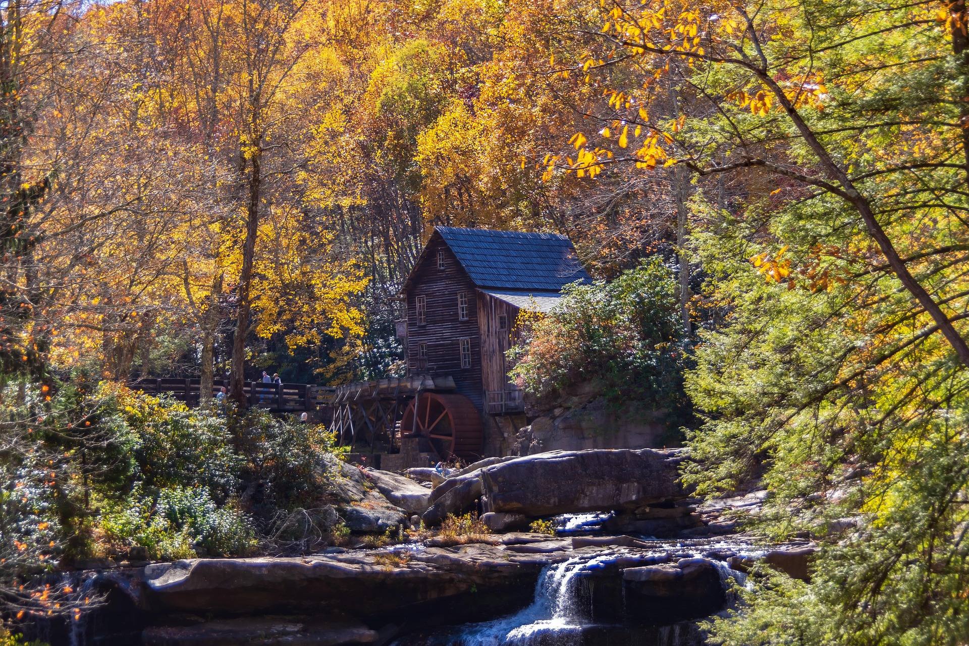
Color moves downhill, not across the calendar
Fall color begins on the highest ridges in late September and moves downhill through late October, reaching the Ohio Valley last. That one sentence is the whole timing model for this state, and it converts a date question into an elevation question.
All terrain in West Virginia above 4,000 feet lies in the Potomac Highlands, including Spruce Knob at 4,863 feet. Travel early in October and go high. Travel late in the month and drop into the gorges and river valleys, where you will still be inside the window while the ridges have gone bare.
Nights are cold and days clear through this stretch, humidity drops and rock friction reaches its annual peak. September and October are also the busiest period of the year statewide, which shapes where you can sleep more than what you see.
Above 4,000 feet: Spruce Knob and the Dolly Sods plateau
At 4,863 feet, Spruce Knob is the highest point in West Virginia and the high point of the entire Allegheny range. A paved road runs to the summit, though the approach is long and winding, and Whispering Spruce Trail 567 loops half a mile through wind-flagged spruce past an observation tower. The summit is frequently in cloud, so check the forecast for the ridge and not the valley.
Dolly Sods is 17,371 acres of federally designated wilderness on a plateau largely above 4,000 feet: wind-flagged red spruce, heath barrens, sphagnum bog and exposed rock. Color here comes from heath and conifer rather than a hardwood canopy, which is a different photograph from the one most first-time visitors expect. Bear Rocks at sunrise is the standard frame, and it means arriving in the dark.
The wilderness holds 47 miles of trail, Red Creek 6.4 miles, Blackbird Knob 4.7 and Rohrbaugh 3.6 among them, all unblazed with unsigned junctions and unbridged crossings. There is no potable water anywhere in it. Unexploded ordnance warnings from wartime artillery training are still posted at trailheads, and Forest Road 75 to Bear Rocks is the most notorious access road in the state.
The byway that peaks first: Highland Scenic Highway
The Highland Scenic Highway is a 43-mile National Scenic Byway climbing over 4,500 feet across the Allegheny plateau between Richwood and US 219, with four major overlooks. Fall color peaks here in early October, before the valleys, which makes it the right target for the first half of the month.
No services exist on the highest section, and the Highlands section, WV 150, is unmaintained in winter. The byway reaches Cranberry Glades, the Falls of Hills Creek and the Cranberry Wilderness, so it supports a full day rather than an hour.
It doubles as one of the best road cycling climbs in the East, with essentially no traffic. Early October brings a rare combination on that road: peak color, a paved climb over 4,500 feet and almost nobody else using it.
Coopers Rock, the Cheat canyon and mid-month color
Coopers Rock State Forest covers 12,747 acres above the Cheat River Canyon, minutes from Morgantown and I-68. The stone overlook stands about 1,200 feet above the river, but it is closed for bridge replacement. Ravens Rock, 1.5 miles out, is the view to walk to instead.
There is real walking here beyond the rim. Virgin Hemlock Trail runs 1.2 miles through a grove over 300 years old, Ken's Run is 4.5 miles and the longest single trail in the forest, and Rock City is a mile through a boulder labyrinth from Picnic Shelter #3. Autumn and winter give the best friction on the sandstone, where several hundred established boulder problems sit.
This is a state forest rather than a state park, which means hunting is permitted in season. Wear blaze orange from October through January on any public land outside a state park, and put orange on your dog as well.
Where the color arrives last: Babcock and the Greenbrier grade
Babcock State Park holds the Glade Creek Grist Mill, the most photographed building in West Virginia, a working reconstruction assembled from parts of three historic mills and sitting on a boulder-strewn creek. Mill photography is best in October with fall color and low sun, which is as close to a published peak date as this subject offers.
The park runs to 4,127 acres and there is more here than the mill. Narrow Gauge Trail follows 2.5 miles of the Manns Creek Railway bed, closed in 1956. Rocky Trail is half a mile of CCC stone staircase between the Skyline and Narrow Gauge trails, and Old Sewell Trail drops nine miles past a coal boiler and waterfalls to a former mining town, crossing into the national park. Manns Creek Gorge trails are steep and rugged.
For a low, level option late in the month, the Greenbrier River Trail runs 78 miles from Cass to Caldwell on a former logging grade that never exceeds about one percent. Droop Mountain Tunnel, 402 feet and built in 1900, sits at mile 30.9; Sharps Tunnel, 511 feet and 1899, at mile 65.2. The surface is quarter-inch limestone crusher run.
What October costs: bookings, crowds and orange
Lodging in Fayetteville, Davis and Marlinton books months ahead for this period. State park cabin bookings open a year in advance, and Babcock, Blackwater Falls, Watoga and Cacapon routinely fill for all of October within days of that window opening. Babcock's cabins are among the most booked in the system.
On the Greenbrier River Trail, shuttle services operate from Marlinton and Lewisburg, primitive campsites with privies sit every few miles, and Clawson at mile 61.2 is reached by five miles of unpaved mountain road. Cell service is absent for long stretches of that corridor and across the Highlands generally, so download offline maps before you leave pavement.
Autumn dry spells turn the Highlands from too wet to burn into genuinely flammable, quickly. Use a stove. And expect company at the photogenic stops: the Almost Heaven Swings sited at overlooks are heavily photographed, with a short wait likely at the best-known ones on autumn weekends.
Reach people planning this trip
Placement alongside guides for outfitters, guides, shops and lodging.
List your business hereQuestions
When is peak fall foliage in West Virginia?
What is the best fall foliage drive in West Virginia?
Do I need blaze orange hiking in West Virginia in October?
Is the Coopers Rock overlook open?
Read next
 Guide
Guide
West Virginia Fall Foliage Guide
Where and when to see fall foliage in West Virginia: how color moves down in elevation, the best overlooks and drives, and why peak dates shift.
9 min read · October
Guide · Greenbrier Valley
The Highland Scenic Highway: Driving and Hiking
A 43-mile byway above 4,500 feet: four overlooks, the Cranberry Glades boardwalk, the Falls of Hills Creek, and the trailheads that close all winter.
7 min read · October
Best of · New River Gorge
The Best Hikes in Babcock State Park
Trail by trail through Babcock State Park, with the state park system's own mileages and ratings for Old Sewell, Narrow Gauge, Skyline and Rocky.
7 min read · October