
Every organization we link to: local tourism offices, the state and federal agencies that manage the land, the nonprofits and clubs that keep access open, and the universities doing the research.
West Virginia has roughly 1.5 million acres of public land and a handful of places that carry almost all of the attention. The consequence is that a great deal of very good ground sits nearly empty, usually for one of three reasons: nobody has heard of it, the road in is gated or rough, or it is undeveloped and has nothing to advertise. Those are the places below — of them across regions.
Almost Heaven Swings
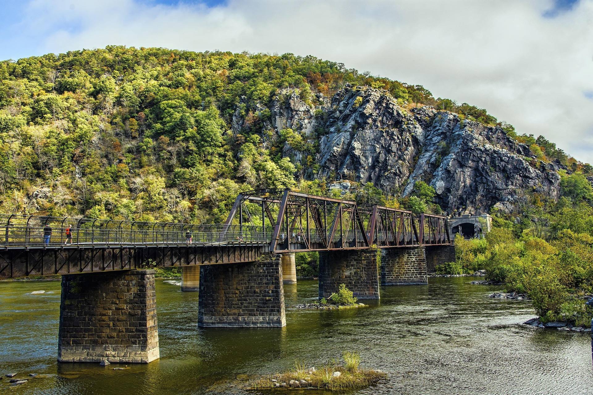
How much trail, and where it runs
The Appalachian Trail in West Virginia is about 24 miles long. It crosses the Potomac at Harpers Ferry, where the Shenandoah comes in and three states are visible at once, and it runs through town between Virginia and Maryland. Twenty-four miles is a small share of a trail that runs the length of the Appalachians, and it is also the most consequential stretch of it for a thru-hiker, because the Appalachian Trail Conservancy is headquartered a block off Washington Street and Harpers Ferry is the trail's psychological midpoint. It is also a share of the trail short enough that most walkers could cover the state in a weekend.
The Conservancy headquarters is free to visit and keeps the thru-hiker photo archive — the run of hikers photographed there season after season. For a section hiker or a day walker, that is the reason to build a trip around the town rather than around the mileage. Twenty-four miles is a weekend at most, and the trail here is less the point of the visit than the thing that happens to run through the middle of it. Nothing about the West Virginia miles is remote: the trail runs past a working town and a national park visitor operation.
Harpers Ferry as a trail town
Harpers Ferry National Historical Park is the trail town, and for anyone arriving by car it operates like a park rather than a town. Parking in town fills early — use the visitor center shuttle. Lower Town holds the historic streets and the water; the Point, where the Shenandoah meets the Potomac, is the classic photograph. The C&O Canal Towpath runs along the Maryland bank, which gives flat walking or riding on the opposite side of the river from everything the trail climbs. The shuttle is the difference between starting a walk at nine and starting it at eleven.
Three states are visible from the confluence and the trail uses the bridge to cross between two of them. For a hiker planning food, water and a bed, a national park town is an easier proposition than most stops on the Appalachian Trail — but the same thing that makes it easy makes it crowded, and the park's advice about arriving early for parking is the practical version of that. The town is also the northern anchor for tubing, rafting and flatwater on both rivers. Resupply, a bed and a shower in one place is why section hikers plan a stop here rather than a pass-through.

The hikes off the trail
Maryland Heights is the one people come for. It is a steep 4 to 5 mile round trip from the Maryland side to the overlook above the confluence, and it gives the aerial-looking view down onto Harpers Ferry and both rivers — the definitive photograph of the town. Adding the Stone Fort loop makes it 6.2 miles with 1,522 feet of gain, which is the full version and a real day's walking rather than a morning's. It starts from the Maryland side of the river, so getting to the foot of it is part of the outing.
Loudoun Heights is the alternative and, for anyone who has already done Maryland Heights, the better one. Split Rock is the highest of the Harpers Ferry hikes, with panoramic views over both rivers and east into Pleasant Valley, plus two more unpublicised viewpoints along the power line cut. It sees a fraction of the people for a comparable payoff. Daylight hours only, and there is no water and no restrooms on it, so carry what you need up. The power line cut is the giveaway on a map, and the extra viewpoints along it are not signed.
Jefferson Rock is the short one: a stacked shale outcrop above Lower Town, reached up the 1810 stone steps past St Peter's. It is the biggest view at Harpers Ferry for the least walking, and it is the right recommendation for families and for anyone who cannot manage Maryland Heights. All three of these start from the same town within a few miles of the bridge, which is the argument for two nights here rather than one. The 1810 stone steps are most of the climb, and they are steep but short, which is the whole trade.
The Appalachian Trail in West Virginia in May
Backpacking season in this state runs April through November at an Intermediate to Advanced level, and May suits the Panhandle miles specifically. The Eastern Panhandle sits at lower elevation with warmer temperatures and lower rainfall than the rest of West Virginia, so it dries out and warms up earlier than the Highlands do. May also puts you in Harpers Ferry while the northbound thru-hiker season is under way, which is most of what makes a stop at the Conservancy office worth the detour. Lower rainfall than the rest of the state also means the tread dries faster here after a wet week.
What is not published here is the backcountry detail. Shelter locations, water sources and camping rules for the West Virginia miles are not in the park or region records — get those from the Appalachian Trail Conservancy directly, in the town where its office happens to be. Do not plan water off a general map in this part of the state, either: streams here come off limestone and some of them go underground and come back somewhere else entirely. The office is on Washington Street and free to walk into, which makes it the cheapest planning stop on the whole trail.
West Virginia's other long trail
If 24 miles is not enough trail, the Allegheny Trail runs roughly 300 miles north to south through West Virginia under the stewardship of the West Virginia Scenic Trails Association. It is the state's own long-distance trail and a different experience from the AT: less traffic, less infrastructure, and stewardship by a volunteer association rather than by a national organization with a headquarters building and a photo archive. Roughly 300 miles against the AT's 24 is the scale of the difference, and the Allegheny Trail runs the length of the state rather than clipping one corner of it.
The backpacking that defines West Virginia is on neither trail. Dolly Sods, Otter Creek, Cranberry, Roaring Plains and Laurel Fork are the wilderness areas that do that, all of them west of here in the Highlands and all of them a different kind of trip. Dispersed camping is permitted across much of the Monongahela National Forest. Water there runs abundant but tannic — filter it and expect it tea-colored. And the wilderness areas are not signed or blazed, by design. None of that is a weekend in a trail town, which is exactly why the Harpers Ferry miles are where people start.
Walking the 24 miles
Nothing in the agency material breaks the West Virginia miles into sections with distances, so a section hike here is planned from Conservancy data rather than from park figures. What the park does publish is the town end of it: the shuttle, the parking problem, the office on Washington Street, and the three overlook hikes branching off within a few miles of the bridge. Distances between road crossings, water, and ground you are allowed to sleep on all fall in that category: the park publishes the town, and the Conservancy publishes the trail.
For a first experience of the trail, that combination is the argument for starting at Harpers Ferry rather than a remote trailhead. You can walk the trail through town, climb Maryland Heights or Loudoun Heights to look down on it, visit the organization that maintains the whole thing, and sleep indoors — and because the Appalachian Trail in West Virginia is only about 24 miles, a weekend of that covers a meaningful share of the state's mileage. Twenty-four miles also means a short car shuttle if you would rather walk the state's whole share in one go.
Reach people planning this trip
Placement alongside guides for outfitters, guides, shops and lodging.
List your business hereQuestions
How many miles of the Appalachian Trail are in West Virginia?
Can you visit the Appalachian Trail Conservancy headquarters?
What is the best hike at Harpers Ferry?
Is there a less crowded alternative to Maryland Heights?
Where do you park at Harpers Ferry?
Are there shelters on the West Virginia section of the trail?
Read next
 Best of · Eastern Panhandle
The Best Hikes at Harpers Ferry
Every Harpers Ferry hike with official NPS distances and elevation gain: Maryland Heights, Loudoun Heights, Jefferson Rock, plus current closures.
8 min read
Destination · Eastern Panhandle
Things to Do in Harpers Ferry
A guide to Harpers Ferry, West Virginia: the historic Lower Town, the best hikes and overlooks, tubing and rafting, the Appalachian Trail and where to start.
8 min read Best of · Eastern Panhandle
The Best Hiking Trails in Berkeley Springs
Trail by trail on Cacapon Mountain and Sleepy Creek Mountain: the four mileages the state park publishes, the drive-up views, and what nobody publishes.
8 min read · October