
Every organization we link to: local tourism offices, the state and federal agencies that manage the land, the nonprofits and clubs that keep access open, and the universities doing the research.
West Virginia has roughly 1.5 million acres of public land and a handful of places that carry almost all of the attention. The consequence is that a great deal of very good ground sits nearly empty, usually for one of three reasons: nobody has heard of it, the road in is gated or rough, or it is undeveloped and has nothing to advertise. Those are the places below — of them across regions.
Almost Heaven Swings
Early May to mid-June is peak breeding song
West Virginia's high-elevation spruce and northern hardwood forests hold breeding birds at or near the southern edge of their range: Cerulean Warbler, Golden-winged Warbler, Hermit Thrush, Northern Saw-whet Owl. The state carries a significant share of the global Cerulean Warbler breeding population, which is why birders travel here rather than to closer forests.
Peak breeding song runs early May through mid-June, and May is the peak of a year-round activity. Cranberry Glades, Dolly Sods and Canaan Valley are the marquee high-elevation sites. Mid-May and late May are not the same trip: the song is up all month while individual sites peak at different points inside it.
Two sources do the local work. The Brooks Bird Club is the statewide birding organization, and WVDNR recommends it as the primary way to connect with other West Virginia birders. For what is being seen this week, eBird's West Virginia hotspot data is the fastest route to a productive morning.
Cranberry Glades on half a mile of boardwalk
Cranberry Glades is the largest area of bogs in the state: 750 acres of sphagnum and cranberry peat holding plant communities left behind after the last glaciation, more typical of Canada than the mid-Atlantic, carnivorous sundews and pitcher plants among them. A half-mile boardwalk crosses two glades, fully accessible, with excellent interpretation.
The adjacent forest holds some of the best breeding-bird habitat in the state, and peak birding at the Glades is late May and early June rather than the first half of the month. Next door is a different level of commitment: Cranberry Wilderness is 47,815 acres of unblazed backcountry, unsigned by design.
Rhododendron at Grandview comes late
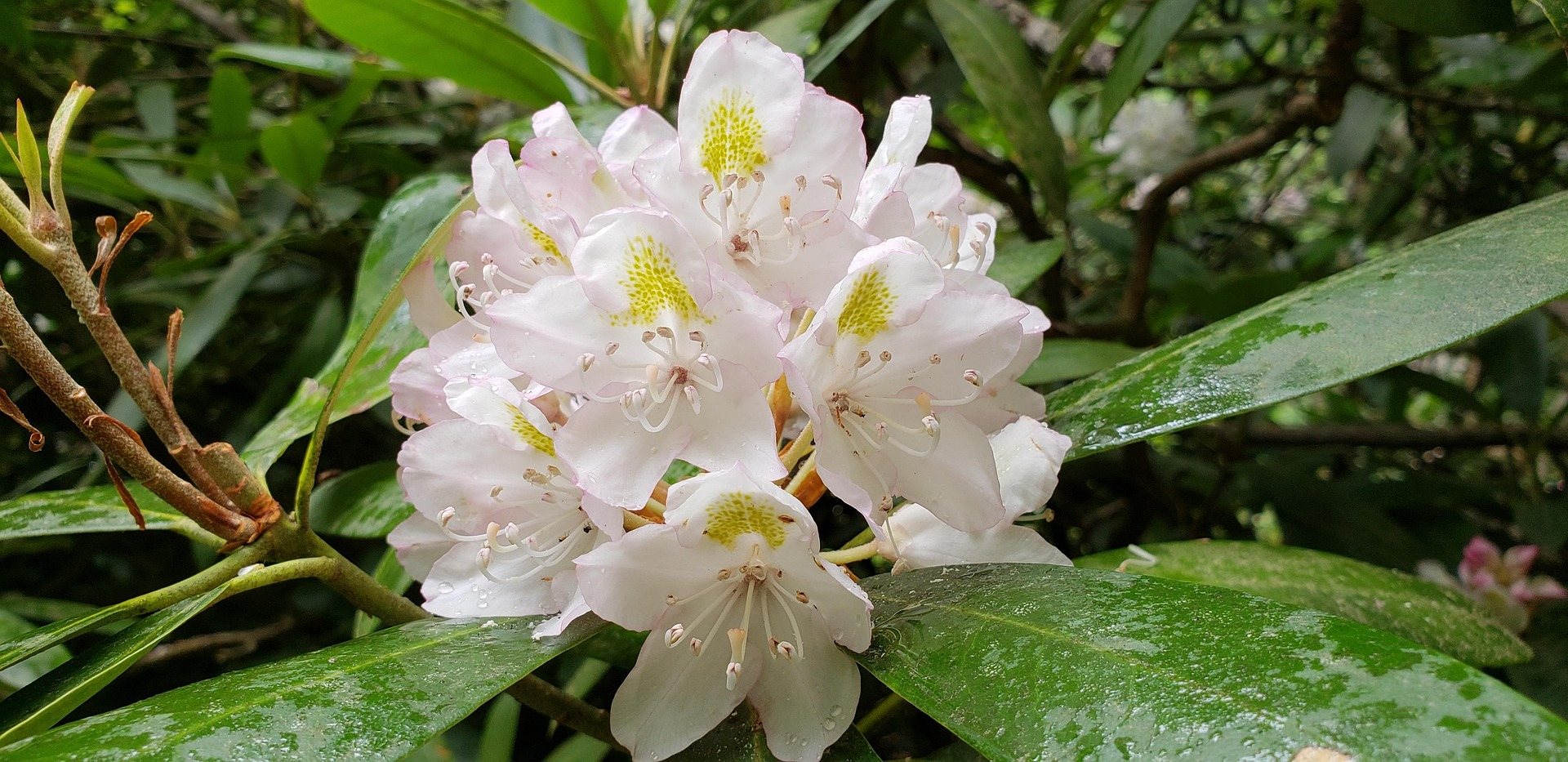
Grandview stands 1,400 feet above a horseshoe bend in the New River, with a seven-mile view up the gorge, the widest perspective in the park. It was a state park before becoming a National Park Service unit, and its rhododendron bloom, in late May and early June, is the best in the state.
Give yourself more than the main overlook. Turkey Spur Overlook is a short drive past the main lot, a 360-degree view from a rock outcrop reached by steel stairs, and the Grandview Rim Trail runs 1.6 miles along the edge. The outdoor drama theatre operates in summer.
Rhododendron thickets are also where you meet snakes. Timber rattlesnake and northern copperhead occur statewide, and thickets and warm ledges are where they turn up, so watch your hands on rock. Ticks are the likelier problem: blacklegged and lone star ticks are active any month above freezing and Lyme rates here are high.
Dolly Sods, in the backpacking window
Backpacking season runs April through November, and Dolly Sods, Otter Creek, Cranberry, Roaring Plains and Laurel Fork are the wilderness areas that define it. Dolly Sods is 17,371 acres on a plateau largely above 4,000 feet, with wind-flagged red spruce, heath barrens, bog and exposed rock, open because the spruce was logged and the duff burned to bedrock a century ago.
It carries 47 miles of trail: Red Creek 6.4 miles, Blackbird Knob 4.7, Rohrbaugh 3.6. Trails are unblazed and crossings unbridged, Red Creek runs tannin-brown, and crossings can be impassable after rain, a live concern in a wet month. There is no potable water anywhere in the wilderness, so carry or treat it, and expect what you filter to be tea-colored.
Camp deliberately. Camping is prohibited within 300 feet of Forest Roads 19 and 75 except at Red Creek Campground, and elsewhere only on durable surfaces, because the bogs are slow to recover. Unexploded ordnance warnings are still posted at trailheads from the plateau's use as a live-fire artillery range in the Second World War. Hypothermia is a real risk in any month.
Plantation Trail and the wet plateau
Canaan Mountain, the plateau between Davis and Canaan Valley at 3,100 to 4,145 feet, is the closest real backcountry walking to the valley lodges. The eight-mile Plantation Trail is the spine, with a dozen connectors and Mountainside, Railroad Grade and Lindy Run as the usual return legs, through rhododendron tunnels, spruce, blueberry heath and old logging grades.
The plateau holds water and is wet underfoot most of the year, so May here means walking wet rather than running a dry ridge. Dispersed camping is permitted across much of the Monongahela National Forest without a permit, subject to setbacks and stay limits, which makes ground like this a workable first night out.
Easy water, and one cold swimming hole
Most paddling in West Virginia is not whitewater. Recreational kayaking runs April through October and suits beginners, and designated water trails on the Coal, Cheat, Elk, Guyandotte, Greenbrier, New and Upper Monongahela give mapped access points, published mileages and hazard information. The Greenbrier and the Cacapon are the gentlest multi-day options.
Lean on local sources: water trail maps from river groups are more current than any national app, and an outfitter will describe conditions faster than a gauge page. Life jackets are required aboard for every person on any vessel, kayaks and canoes included, and levels change in hours after rain.
Blue Bend Recreation Area on Anthony Creek is the swimming answer, though the water is cold well into summer. CCC-built in the 1930s, it is a deep green pool below a stone-walled beach, and the Blue Bend Loop is Trail 614, five miles with three overlooks and a shelter. The campground has 23 mostly nonelectric sites at $16, or $20 with electric, and no potable water. The Forest Service lists it open late March into November.
Climbing before the humidity
Sport climbing season runs March through November, spring and fall prime and summer humid and greasy, which puts May in the good half of spring. The New River Gorge is the anchor: hard, technical, sharply featured Nuttall sandstone with a reputation for steep, powerful lines. Summersville Lake adds lakeside sport and deep-water soloing, and the Meadow River has been one of the East's most significant new-route developments of the past decade.
Research access first. Some cliffs sit on private land, access is a privilege groups renegotiate annually, and some crags close seasonally for raptor nesting or at a landowner's request. The New River Alliance of Climbers keeps the access database to check before you drive.
Reach people planning this trip
Placement alongside guides for outfitters, guides, shops and lodging.
List your business hereQuestions
When is the best time for birding in West Virginia?
When does rhododendron bloom in West Virginia?
Do you need a permit to backpack Dolly Sods?
Can you swim in West Virginia in May?
Read next
 Destination · Potomac Highlands
Hiking Dolly Sods
A practical guide to hiking Dolly Sods Wilderness: the main trails, route options, why it is navigationally serious, and how to reach Bear Rocks.
9 min read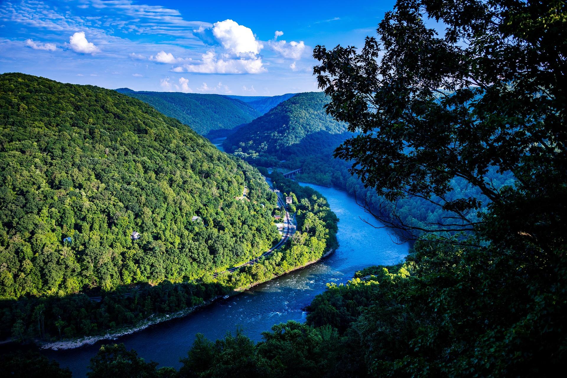 Guide · New River Gorge
Hiking at Grandview in the New River Gorge
The rim trail, Turkey Spur's steel stairs and the late-May rhododendron at Grandview, 1,400 feet above the New River's long horseshoe bend.
7 min read · May Guide · Greenbrier Valley
The Highland Scenic Highway: Driving and Hiking
A 43-mile byway above 4,500 feet: four overlooks, the Cranberry Glades boardwalk, the Falls of Hills Creek, and the trailheads that close all winter.
7 min read · October